
You know a pothole when you hit one.
They jar your car (hopefully no more than that) and can bump drivers and passengers about when they are deep enough. Sometimes they seem to crop up out of nowhere (have you checked out Sisson Avenue anytime recently?).
But can artificial intelligence take a look at a road and detect potholes before they become a problem?
Hartford might find out soon. (Or maybe at least get started finding out)
Cyvl, which calls itself an “AI infrastructure intelligence company” said it would bring scanning technology to Hartford’s Main Street, Central Row, and Asylum Street, today Wednesday, October 15, according to the company.
“The goal is to help city officials detect potholes, cracks, and other surface issues early – before they become costly repairs or safety hazards – and to show how data-driven insights can make roads across Connecticut safer and more reliable,” according to the tech company, which also notes it was founded by two Connecticut natives.
The company said it has raised $25 million to bring its work to “more than 1,000 cities and towns across” the country.
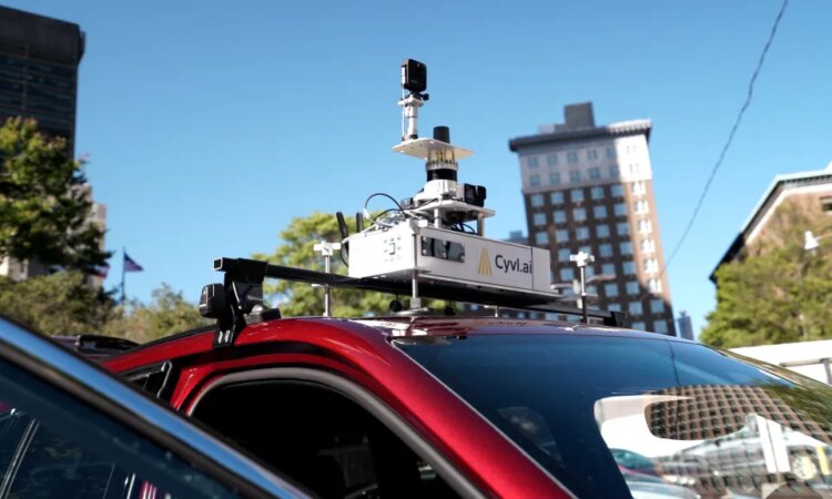
Its notes its “compact, sensor-equipped vehicles capture high-fidelity maps of streets and sidewalks, allowing AI to identify surface damage, hazards, and maintenance priorities.”
“I started my career on the Southbury DPW road crew right here in Connecticut, so I know the pride, and frustration, that comes with trying to keep roads safe with limited tools and data,” said Daniel Pelaez, CEO and co-founder of Cyvl, in a statement. “When you don’t have a clear picture of what’s happening on the ground, it’s hard to stay ahead of problems.”
“By scanning Hartford’s Main Street, we’re showing how cities across Connecticut can use real data to prevent accidents, protect drivers, and plan repairs before they become emergencies. This is about making our communities safer, not just more efficient.”
The Hartford scans are intended to bring results to local and state officials to “demonstrate how AI-powered infrastructure data can support safer, more reliable streets,” according to the company.
Pelaez and co-founder, Noah Budris, grew up in Oxford, and that is where “the idea for Cyvl first took shape,” according to the company. The work Pelaez did with the Southbury DPW road crew showed “him firsthand how difficult it can be for local teams to maintain safe roads without accurate data.”
Cyvl already works with several Connecticut communities, according to the company. A spokesman said the company does “the scan in the area to show what’s possible with the tech.”
Lenny Speiller, a spokesman for New Haven, said, “they are not a company that is directly contracted by the city as far as I’m aware, but it’s possible they might be a subcontractor or technology utilized by a company we contract with.”
Speiller added, “An engineering firm called the BETA Group does an annual assessment of city streets and road surface conditions to help inform the selection of roads that need to be repaved.”
A Hartford spokesman also said he was not aware of the company working with the city.
A Cyvl spokesman said Hartford “was included as one of the 200+ communities we’re mapping as part of this broader campaign, which spans every state capital and many major metros. The goal isn’t to evaluate or publish any type of ranking, but rather to showcase how cities like Hartford are embracing innovation to fix the basics faster, do more with existing budgets, and improve the daily experience for residents.”
The spokesman also said the work is being done independently, at no cost to the cities, “to help highlight the growing role of infrastructure technology in strengthening communities.”
Cyvl is headquartered in Massachusetts and use “compact LiDAR and high-resolution imaging mounted on ordinary vehicles,” the obtain “up-to-date insights into roads, sidewalks, and public assets,” according to the company.
The data is used “for condition scoring, safety prediction, and capital planning,” according to the company.
Originally Published:


